


Latest


circa 1970
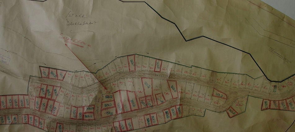
Below left, 1968: Plot Map of Tunstall Bay Lot Developments. Below right, 1974: Aerial View of Bluewater, Bowen Bay and Tunstall Bay. Although Bluewater was developed in the 1950’s, Tunstall Bay wasn’t subdivided until 1969, when Dee Cee Projects planned residential, condos and commercial lots for the area. Like other neighborhoods on Bowen, the plan was for community amenities (tennis courts, a pool etc.) to be for members only. In the aerial view below, the roads leading into the subdivision can be clearly seen.
")
")
circa 1960
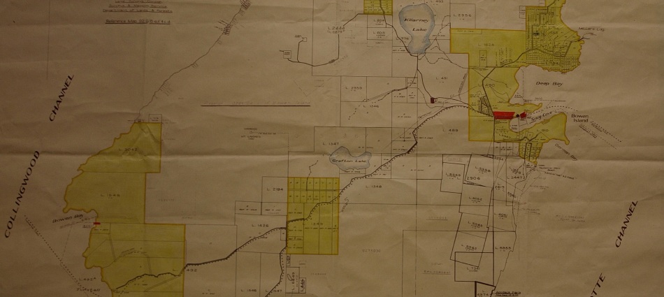
c. 1960: General Land Use and Zoning. Four categories of land use are shown here: residential, commercial, industrial and rural. This map highlights the transition from resource extraction/industrial land use that dominated Bowen’s early history to a largely residential/rural island with developed blocks of neighborhoods: Hood Point, Miller’s Landing/Scarbourough/Eaglecliff/Deep Bay/Snug Cove, Mt. Gardner Park, and Bowen Bay/Tunstall Bay/Bluewater, and Cowan’s Point. Here, only a few small tracts of land show industrial land use (indicated by the darker red colour) are shown, while rural (white) and residential (yellow) dominate the map. 
1962
Bottom left, 1962: Plan of Subdivision of District Lot 490 between Snug Cove and Deep Bay. Top left, 1962: Aerial View of Snug Cove and Deep Bay, showing major changes. Bottom right, 1963: Subdivision Plan of District Lot 1628 and 49 at Miller’s Landing. Top right, 1962: Aerial View of Miller’s Landing. The year 1962 saw a major transition in land use, when the Union Steamship Company put their Snug Point subdivision on the market, thus drawing to a close the booming resort industry. The 17 acres between Snug Cove and Deep Bay, where the dance pavilion, bandstand, tearoom and picnic ground were was sectioned into private residences. Along the south side of Deep Bay, one lot along the beach was saved for public access (today, Sandy Beach) and one was bought by the the CNIB camp (open 1963). The Deep Bay and Miller’s Landing subdivision occured in 1964, occupying the land where the number 3 picnic grounds were. The bottom left aerial view shows the store in the original site, the Lower Dance Hall still there and the new CNIB lodge. The inside wing of the original steamer dock is gone, as is the hotel, but three of five tennis courts at the resort still remain, as do Evergreen Hall and the Men’s Dorm. The passenger ferry dock and log booms can be seen in Snug Cove.


1950’s & 1960’s (2)
Below left, 1951: Map of Bowen Island showing Bowen Island Waterworks Ltd, Bowen Estates and Union Steamship Company holdings. Below right, 1958: Union Steamships Ltd, showing boundaries. These maps show the extent to which the Union Steamship Company monopolized land on Bowen Island, or at least the side of the island most popular as a tourist destination.


1950’s & 1960’s
Below left, 1950’s: Evergreen Park Resort. Below right, 1959: Aerial View of Snug Cove and Deep Bay. The resort business was still going strong at the end of the 1940’s, with Evergreen Park Resort as the destination. However, the Union Steamship Company began to restrict access to the hotel and grounds, picnic tables were taken from the picnic grounds, and the dance hall was closed. In 1957, Evergreen Resort closed, although 180 cottages were still available for rent from the estate. In 1962, the hotel was demolished, and most cottages fell into abandon, especially on the north side of government road. The advent of the car during this time meant that people wanted to travel further afield for holidays; Bowen Island’s land was no longer the ultimate paradise, although of course, many on-foot tourists still visit today. In the aerial view, the picnic grounds and resort are still visible, and most of the private lots and buildings seen today are not there (Miller’s Landing, Cates Hill, etc.) In contrast to previous photo’s, Snug Cove has been dredged by this time.


1950’s
Below left, 1952: South End of Bowen Island. Below right, North-east Bowen Island. The view of the south end of Bowen Island shows Apodaca Park, deeded to the provinical government by JS Matthews in 1954. The 1950’s mark the start of Bowen Island’s land being considered for provincial and regional parks.


circa 1950 (3)
c. 1950: Landscape of Mt. Gardner and surrounding area. Forestry has been a relatively continuous use of the land since Bowen Island was first ‘discovered’ by settlers of European descent. Here, the effects on the landscape of logging can clearly be seen. Killarney and Grafton Lakes can be seen, as well as a farm in the bottom right-hand corner of the image.
circa 1950 (2)
Below left, 1947: Bowen Island. Below right, 1949: Map of Bowen Island, New Westminster District. The New Wesminster map of Bowen’s legend shows logging roads, as well as power and telephone lines. Distinct neighborhoods of denser lots and residences can be seen at Cowan’s Point, Hood point, Mt. Gardner Park, and mid-island, although notice that Bluewater is in the early stages of subdivision, while Tunstall Bay has not yet been subdivided. Small lots are shown directly north of Mt Gardner’s summit, but the most populated part of the island is still the east coast closest to the boat access from Vancouver. There are still many large lots shown, particularly at Cape Roger Curtis and where the Ecological Reserve is today. 

1949: Map of Bowen Island, Group 1, New Westminster District showing district lots, road types and power lines. j c. 1947: Aerial View of Bowen Islandc. 1947: Aerial View of Bowen Island
